
Mr. Blair Kooistra is a fellow railfan who has a good eye for machinery. He admits to putting worthy effort into even the simplest of railroading photos that he uploads. His collection of photographs online is nothing short of beautiful.
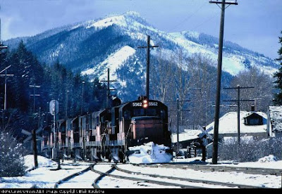
Blair was also on-hand to see the final hours of the Milwaukee Road in Washington when he took this simple photo in Easton WA on March 14, 1980. After that the lines in-state were either abandoned or sold to the Burlington Northern. In this photo you will see a long line of motive power, likely with many of the engines "dead in tow" to the Milwaukee's lines east of Montana. With Easton being within 70 miles of my home, I thought it would be fun to try duplicating Blair's photo almost 28 years later.
Turns out it wasn't as easy as I thought it would be.
My sons and I headed to Cabin Creek Rd. just south of downtown Easton and crossed the BNSF Mainline that still runs through. The Milwaukee Road, in this part of the state, has been replaced by the Iron Horse State Park which runs from North Bend to the Columbia River; it ran a few steps south of the BN at that time. This made Easton a true railroader's town. David and I got out of the truck with Blair's photo and started matching up landmarks. Much had changed and it didn't help that clouds were obscuring the hills to the north. As David and I were scratching our heads trying to find the right angle, to our fortune a woman was crossing the tracks and asked if we were waiting for the train. I told her what we were doing and she asked to see the photo. "I've lived in Easton all my life, and live in the oldest house in town." How cool is that? Right away she found the Tavern; it is to the right of the loco in the original photo with a centered chimney. In my photo below it has a red roof. She also showed us that the railroad crossing signs in Blair's photo were gone and that the fire station now had a new roof.
 Then and Now Mission completed, even if my current-day photo lacks the sizzle of the original. But now the mystery starts. In Blair's photo it looks like the Milwaukee was running on Burlington Northern trackage at the time, based on what I saw yesterday. Could this be? Was there possibly one of the many derailments that plagued the MILW towards the end that sent these engines to BN tracks? Or did the Milwaukee in fact run in a different place that I miscalculated? That is a mystery that can be solved by someone who knows the route far better than me.
After visiting Easton, we headed to South Cle Elum for a photo shoot with a MILW bayside caboose. It was a great day following in the footsteps of The Road!


Curt,
ReplyDeleteYou're close but not quite there. The train was indeed operating on the Milwaukee Road tracks, which as you mentioned are just a couple hundred feet south of the BNSF ex-NP tracks in town. You can see the separate pole line for the BN tracks in the background.
I'd send you a good Google map with an aerial view, but the coverage isn't that good there. . .but looking at the map itself, the grade crossing in the background is Cabin Creek Road. If I recall correctly--it's been 27 years, ya know--after crossing the Milwaukee tracks, we turned east on the parallel dirt road, and set up our cameras a few hundred feet east of the grade crossing. The photo was made with a 300mm lens (I loved big telephotos back then).